
Florida leads the U.S. in the recorded number of sinkholes, thanks to its unique karst topography. This has obvious implications for roadways across the state. If the ground collapses under a roadway, the results could be tragic. Predicting where sinkholes might happen can potentially save infrastructure and lives.
But is it even possible to predict sinkholes?
Researchers from the Florida Department of Transportation (FDOT) and the University of Florida (UF) set out to test a novel approach to detecting sinkholes – using traffic noise.
CT Scans for Roadways?
Sinkhole risk is widespread in Florida.
“Quite a bit of Florida has limestones at near the surface, and we feel the effects of sinkholes for a good part of the state,” said David Horhota, a geotechnical materials engineer with the Florida Department of Transportation (FDOT). “Interstate 4 corridor, I-75 corridor, I-10 to the panhandle of Florida – all have a sinkhole active area.”
that used ambient noise—specifically, traffic noise—to locate and model subsurface voids that could lead to sinkholes. While traditional methods for detecting voids can be invasive and require road closures, this approach could be a game-changer.
When captured on geophones, traffic noise creates both high and low frequency sound vibrations, which can then be assembled using tomography to create a three-dimensional image of any subsurface voids.
“It is similar to other medical imaging in that we need to find the problem using a non-invasive approach,” said Dr. Khiem Tran, associate professor in the Department of Civil and Coastal Engineering at the University of Florida and principal investigator on the project. “And we want to identify the problem before it collapses.”
It’s like a CT scan for a roadway.
“We put the sensor on the pavement and then measure the signal in use by the vehicle passing by,” Tran added, “and then do some signal processing to identify the void under the roadway.”
Better Pictures, Deeper Holes
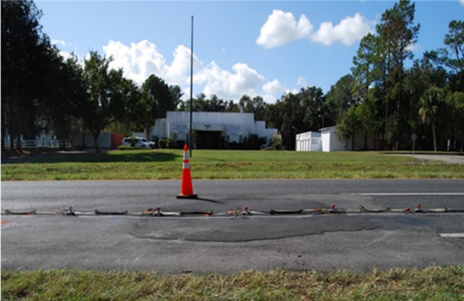
During the research process, the team performed tests at four field locations where voids had been found during the construction or maintenance of a road. At each site, 24, 36, or 48 detectors spaced at five feet along a line were used to collect traffic noise. When compiled together, the data collected gave subsurface profiles that generally agreed with other more time-consuming, more expensive methods.
Using tomography, subsurface data can be collected within minutes, Tran said, depending on how long it takes for a truck or two to pass and generate the necessary ambient sounds. It can also reach greater depths than traditional methods, which generally can capture 20-60 feet beneath the ground surface.
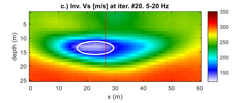
“We could go down to 100 feet with our research measurement of noise,” Tran said. “If we do the invasive (traditional method) down to 100 feet, it will be very costly.”
If adopted at the local level, tomography technology could eliminate the guesswork and significantly change how roadway planning is carried out.
For instance, in areas with limestone closer to the surface, like in Hillsborough, Pasco, and Hernando counties—AKA Florida’s “Sinkhole Alley”—sinkholes occur more frequently and have more severe ramifications. The area accounts for more than 60% of all sinkhole activity in Florida.
The tomography method could save sinkhole-prone counties from future damage to their infrastructure, meaning we could see a disappearance of sinkholes for roadway infrastructure.
“If you get this quicker, faster, better picture of what’s happening in the ground, the engineer has better information to assess the site conditions and know if they must act right away there,” Horhota said. “Hopefully, it gives them better information to know exactly what’s the best remediation to fix sinkholes.”
Getting Ahead of the Holes
This method could also change the design of infrastructure because tomography looks deeper into the subsurface area. The ambient noise technology is currently being used in the field by FDOT and is expected to be adopted more widely in Florida as well as in other sinkhole-prone states across the Southeast U.S.
“If we have the technology, then we can detect it,” Tran said. “If we go to the site and do the imaging and the site is good, we can build a bridge. If there’s a void, we shouldn’t build anything on top of the void. If we use the technology, we can avoid a sinkhole collapse.”
Further Reading
BDV31-977-122 2022 In-service Assessment of Road Sinkholes with 2D Ambient Noise Tomography Final Report | Summary
