
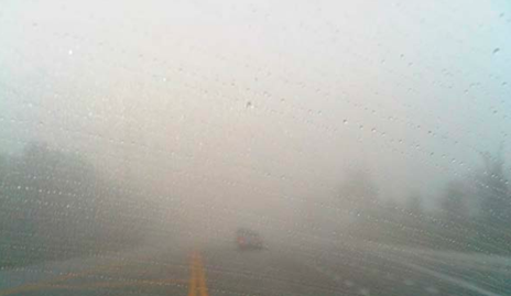
In January 2012, fog and smoke took over Interstate 75 outside of Gainesville, leading to a 19-vehicle pile-up, 11 fatalities, and 18 hospitalizations. Low-visibility road conditions due to fog and/or smoke are a major concern in Florida, as this crash was not the first or last incident to occur. The National Highway Traffic Safety Administration (NHTSA) reports Florida as one of the top states in the nation with fatal crashes due to low visibility conditions, from fog or smoke to heavy rain. FDOT is prioritizing how to better understand when and where low visibility occurs to warn drivers more efficiently of these dangerous roadway conditions.
A Foggy History
The Federal Highway Administration states fog impacts many aspects of a transportation system, from its roadway and traffic flow to operational performance. Fog changes driver behavior, causing drivers to vary their speeds. This differential in speed, combined with fog-induced low visibility, creates dangerous road conditions. Fog is a common weather phenomenon that forms when there is increased humidity and moisture levels in the sky, and temperature differential between the ground and the sky. It is also found to occur with low wind speeds and dew-point temperatures. These parameters were analyzed to predict low visibility on highways through the past research of co-Principal Investigator Dr. Abdel-Aty, of the University of Central Florida. He explained his work, saying, “We installed visibility sensors at selected locations in Florida and collected data of traffic flow characteristics as the visibility levels were dropping. We identified the locations and times when fog was more prone.”
“This research was beneficial and applicable for FDOT,” Project Manager Fred Heery at FDOT commented, “We have used precipitation and moisture meters in the past to attempt to predict when fog could occur; however, these measures helped us predict – not obtain real-time data. The regional traffic management systems around the state would receive many false alarms based on the system’s predictions, to the point where it was turned off.”
In addition to the lack of real-time data, FDOT was interested in maximizing a statewide understanding of fog/smoke conditions, determining where common hotspots are for low visibility related crashes. Fred Heery explains, “We wanted to check to see what the status is of these crash locations. We know how to treat roadbeds for other weather conditions, but we can’t eliminate fog – we can only warn drivers about it.” Therefore, FDOT worked with Principal Investigators Drs. Jaeyoung Lee and Abdel-Aty of the University of Central Florida to investigate where low-visibility hotspots are across the state.
Analyzing Hotspots
The research team approached this question on two levels, first trying to capture and process data through a macro-level (or broad) analysis, then performing a more detailed micro-level analysis.
Before diving into crash rates, the team analyzed existing crash data between the years 2013 and 2017 on fog/smoke related crashes to pull crash trends and characteristics. Through the data analysis, the research team determined that fog crashes mainly occur between December and March. December had the highest crash rate at twenty-six (26) percent of all low visibility related crashes. They also determined that most fog and smoke-related crashes occur between 5 a.m. and 8 a.m.
At the macro-level, the team reviewed statewide crash data to determine crash density rates, using the kernel density estimation. The top eight “clusters” selected were counties with the highest crash density rates. These counties consisted of Duval, Orange/Osceola, Pinellas/Hillsborough/Polk, Lee, Escambia, Alachua, Leon, and Miami-Dade.

A micro-level analysis was then completed for each of these counties. This included plotting the crashes between 2013 and 2017: identifying the specific intersection, ramp, or one-mile roadway segment where the crash occurred. Locations with repeated (two or more) crashes due to fog or smoke were documented as hotspots. In the end, 49 intersections, and 45 freeway/expressway ramps, and 81 one-mile segments were identified as hotspots.
Looking Ahead
The efficiency of this two-tiered analysis approach enables FDOT to regularly screen macro-level crash data and focus attention in specific locations where fog-related crashes have occurred, with the goal of reducing crashes and fatalities caused by fog or smoke. Understanding where low-visibility conditions are common, from the county level as well as the specific segment of roadway, takes this research from a much broader idea to a detailed micro-level analysis. This analysis gives Florida the ability to determine where to install potential preventative safety measures based on number of crashes. “We have a lot of roadways to stay on top of,” Heery acknowledges.
With this study completed, FDOT is now tracking and tackling all they can on low-visibility conditions caused by fog or smoke. Eugene Jules of FDOT’s Traffic Engineering and Operations Office is managing an ongoing study with the University of Central Florida, this time seeing if they can detect fog in real time. Fred Heery explains, “The research Eugene is working on now measures fog in real time using light beams, measuring light diffusion from one detector to another.” Eugene adds, “FDOT is always trying to improve advance notification systems.” This project allows for an updated proactive approach instead of a reactive approach. FDOT looks forward to having the ability to measure when and where low-visibility conditions could occur, and to effectively warning drivers in real time of approaching low-visibility conditions.
Further Reading
BDV24-977-31 Investigation of Low Visibility Related Crashes in Florida
Summary | Final Report
BDV24-962-01 Real Time Monitoring and Prediction of Reduced Visibility Events on Florida’s Highways
Summary | Final Report
BDK83-977-19 Analysis of Prospective Systems for Fog Warnings
Summary | Final Report
